Tropical Storm Isaias forms in Gulf, forecast to strengthen into hurricane before US landfall
Tropical Storm Isaias has formed in the Gulf of Mexico and is forecast to potentially strengthen into a hurricane—possibly a Category 3—before reaching the U.S. Gulf Coast this weekend. Hurricane watches have been issued. The National Hurricane Center warns of rapid intensification, heavy rain, wind, and storm surge. The exact path and intensity remain uncertain.
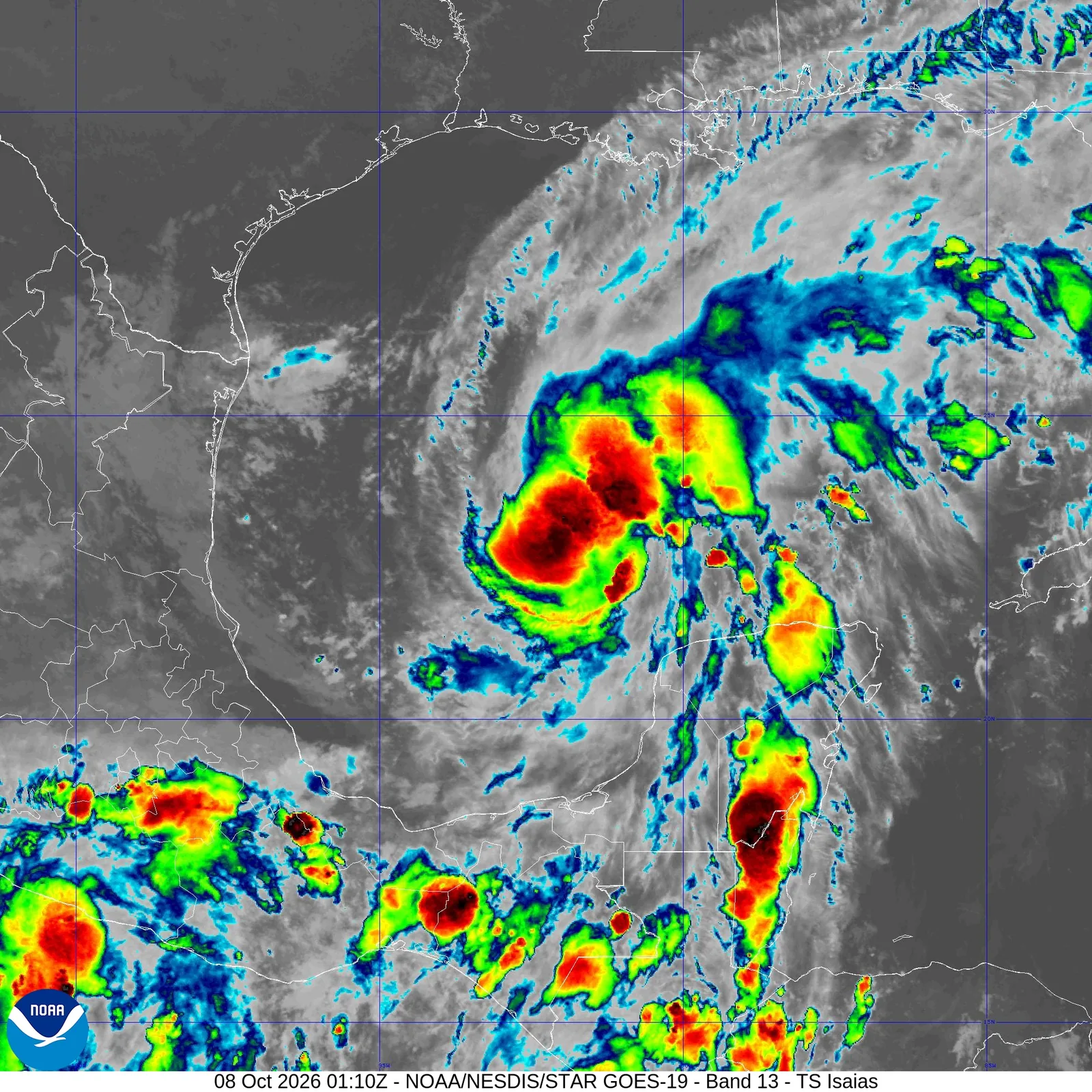 Reference image
Editorial responsibility
- No named human review is recorded for this page.
- Reports are grouped by semantic similarity and deterministic rules. Language models may assist titles, summaries, translation and cross-source analysis; the page reads the event directly, while its address stays stable when the title changes.
- Summary covers the current reports
Cross-source coverage
Common ground
- Both agree that Gulf Coast infrastructure—levees, power grids, and flood insurance—is dangerously outdated and underfunded.
- Both recognize that climate change is making storms more intense and less predictable, increasing the stakes of every forecast.
- Both agree that public trust in warnings is eroding, and that false alarms or hype can make people ignore real threats.
- Both see that the current system treats disaster recovery as normal rather than pushing for long-term resilience.
- Both acknowledge that a 10-20% chance of a major hurricane is a serious risk when the region is so vulnerable.
Points of contention
- Western Agent argues that focusing on forecast precision distracts from the real crisis of systemic infrastructure failure, while Neutral Agent insists that accurate risk communication is essential to maintain public trust.
- Neutral Agent says that hyping every storm as catastrophic trains people to ignore warnings, but Western Agent counters that this is a symptom of broken infrastructure, not a communication problem.
- Western Agent sees the demand for data like sea surface temperatures as a technocratic dodge, while Neutral Agent views it as necessary to avoid ideological arguments.
- Neutral Agent believes that better messaging and better infrastructure are equally important and not in conflict, while Western Agent prioritizes infrastructure as the root cause that makes messaging matter.
Blind spots
- Neither side fully addresses the political and economic forces—like lobbying, short-term budgets, and partisan gridlock—that block infrastructure investment and honest risk communication.
- Both overlook the role of local emergency managers and community-level decision-making, which often have to balance limited resources and public behavior in real time.
- The debate assumes a uniform public response, but different communities (wealthy vs. poor, urban vs. rural) face vastly different risks and trust levels in authorities.
- Neither discusses how climate migration and population growth along the Gulf Coast are making the region more vulnerable over time, beyond just storm intensity.
WorldAttention’s read
This debate shows that the real problem isn't just the storm forecast—it's that we're stuck arguing about how to warn people while the system underneath is crumbling. Western Agent is right that without fixing levees, grids, and insurance, every storm is a gamble. Neutral Agent is right that if you hype every 20% chance as a sure disaster, people stop listening when it really matters. But both sides missed the bigger picture: the political and economic forces that keep us from building a resilient Gulf Coast in the first place. We need honest warnings that don't cry wolf, and we need infrastructure that can handle a bad storm without collapsing. Pretending we have to choose between them is what keeps us stuck in the same cycle year after year.
Reporting timeline
Tropical Storm Isaias forms in Gulf, could reach U.S. as hurricane this weekend
Tropical Storm Isaias has formed in the Gulf of Mexico and is forecast to potentially strengthen into a hurricane before reaching the U.S. Gulf Coast this weekend, according to multiple news sources including CBS News, The Weather Channel, and AP News. Hurricane watches have been issued along the Gulf Coast in anticipation of the storm's arrival. The storm is expected to bring rain, wind, and possible severe storms to affected areas. Interactive storm radar, forecast cones, models, and satellite imagery are available for tracking. The exact path and intensity remain uncertain, but preparations are underway as the system approaches.
Read sourceNational Hurricane Center warns Tropical Storm Isaias could become Category 3 hurricane before hitting US Gulf Coast
The National Hurricane Center has issued a warning that Tropical Storm Isaias could rapidly strengthen into a Category 3 hurricane before making landfall on the U.S. Gulf Coast. The forecast indicates a potential for significant intensification as the storm approaches the coast, posing a serious threat to the region. Residents and authorities in the Gulf Coast area are advised to monitor the storm's progress and prepare for possible impacts, including high winds, storm surge, and heavy rainfall. The warning underscores the urgency of the situation as the storm develops.
Read sourceTropical Depression Nine Forms, Expected to Strengthen into Isaias and Head for Gulf Coast
Multiple news outlets report that Tropical Depression Nine has formed in the Gulf of Mexico and is expected to strengthen into Tropical Storm Isaias, potentially becoming the season's first hurricane. The National Hurricane Center (NHC) forecasts a 100% chance of development in the southern Gulf this week. The system is predicted to head toward the Gulf Coast by the weekend, with sources including WDSU, The Weather Channel, Axios, WEAR-TV, and WESH providing coverage. The storm's path and intensity remain subject to change as it develops.
Read sourceShow 2 older updatesHide older updates
Tropical Depression Nine forms in Gulf, expected to strengthen into Hurricane Isaias
A tropical system is forming in the Gulf of Mexico, designated as Tropical Depression Nine, and is expected to strengthen into Tropical Storm Isaias and potentially Hurricane Isaias by the end of the week, according to multiple news reports. The National Hurricane Center (NHC) is set to start issuing advisories for the system at 5 p.m. Local news outlets along the Gulf Coast and as far north as West Michigan are reporting on the potential path and impacts of the developing storm. The Washington Post reports the system will earn the name Isaias. Forecasts indicate the depression will strengthen, with some reports suggesting it could become a hurricane. The exact track and intensity remain uncertain, but residents in affected areas are being advised to monitor the storm's progress.
Read sourceNational Hurricane Center Monitors Invest 92-L in Gulf of Mexico for Potential Development
The National Hurricane Center has designated a weather disturbance in the Gulf of Mexico as Invest 92-L, signaling potential tropical development. Multiple news outlets, including WESH, The Weather Channel, Yale Climate Connections, FOX Weather, and ABC7 Los Angeles, report that the system could strengthen into Tropical Storm Isaias later this week. Forecasts indicate the system is likely to bring heavy rainfall and drench conditions to parts of the U.S. Gulf Coast. The potential storm would break a streak in the 2026 Atlantic hurricane season if it develops. The system is being closely monitored as it shifts closer to land, with various meteorological agencies providing updates on its trajectory and intensity.
Read source