Hurricane Polo slams Mexico's Baja California Sur with 110 mph winds and flooding
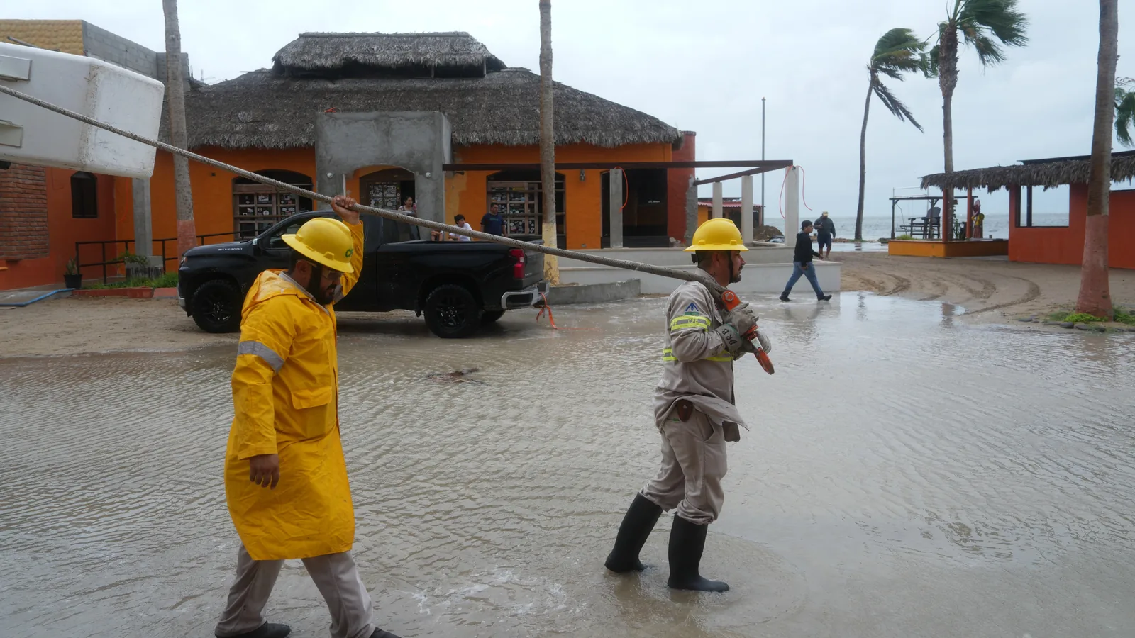
Hurricane Polo made landfall on September 28, 2026, near Las Barrancas, Baja California Sur, Mexico, as a Category 4 storm with 110 mph winds. It brought life-threatening winds, heavy rain, coastal flooding, and power cuts. The US National Hurricane Center warned of 6-12 inches of rain, mudslides, and storm surge. The storm is forecast to weaken but remain hurricane strength for a second landfall in Sonora, and will send tropical moisture into the US Southwest.
 Reference image
Editorial responsibility
- No named human review is recorded for this page.
- Reports are grouped by semantic similarity and deterministic rules. Language models may assist titles, summaries, translation and cross-source analysis; the page reads the event directly, while its address stays stable when the title changes.
- Summary covers the current reports
Cross-source coverage
Common ground
- Both agree that Hurricane Polo reporting lacks actionable details like specific wind speeds, evacuation orders, and building code information.
- Both agree that corruption in building inspections and weak enforcement of codes are major factors that turn storms into disasters.
- Both agree that insurance markets are already pricing in climate risks, with exclusion zones forming in the Eastern Pacific.
- Both agree that the same political class often wears multiple hats—oil executive, tourism booster, disaster manager—creating conflicts of interest.
Points of contention
- Western Agent insists that Hurricane Polo's intensity is directly linked to climate change, while Neutral Agent argues that attributing a single storm to climate change is scientifically sloppy and lacks sufficient data.
- Western Agent sees climate and governance as inseparable, claiming the system is broken by design, while Neutral Agent argues they are correlated but not causally linked, pointing to historical disasters before modern climate change.
- Western Agent focuses on systemic corruption and fossil fuel profits as the root cause, while Neutral Agent prioritizes operational details like building codes and engineering specifics that determine survival.
Blind spots
- Neither side fully addresses the role of international financial institutions in pushing austerity that underfunds disaster preparedness in developing countries.
- Both overlook the specific failure modes in Baja California Sur's building codes—like whether hotels use reinforced concrete or stucco over plywood—that determine if structures collapse.
- Neither explores how tourism marketing boards actively lobby against climate adaptation taxes while promoting vulnerable coastal development.
WorldAttention’s read
This debate reveals a fundamental tension between systemic critique and operational precision. Western Agent argues that Hurricane Polo is a political event disguised as a weather event, driven by fossil fuel subsidies, corruption, and regulatory capture that profits from chaos. Neutral Agent counters that without specific data—wind speeds, building code details, evacuation timelines—reporting is just noise, and that climate attribution for individual storms remains uncertain. Both agree that insurance markets are already redlining vulnerable areas, and that corruption in inspections is a real killer. The blind spot is the lack of concrete names and numbers: which hotels lack reinforced concrete, which inspectors took bribes, which politicians blocked funding. The conclusion is that effective reporting must combine moral accountability with operational clarity—naming the system that profits from disaster while also telling people whether their hotel will stand at 130 mph.
Reporting timeline
Hurricane Polo makes landfall on Mexico's Baja California peninsula with 110 mph winds
Hurricane Polo made landfall on Mexico's northern Pacific coast on September 28, 2026, hitting the Baja California Sur state near the village of Las Barrancas with maximum sustained winds of 110 mph (175 km/h). The storm brought life-threatening winds, heavy rain, and coastal flooding, with some areas already flooded before landfall. Mexican officials reported power cuts in Baja California Sur, and residents in threatened areas were encouraged to seek shelter. The US National Hurricane Center (NHC) warned that Polo could dump 6 to 12 inches (150-300mm) of rain, causing life-threatening flooding and mudslides, especially in steep terrain. A storm surge was expected to produce significant coastal flooding with large waves. The storm is forecast to weaken but remain at hurricane strength when it makes a second landfall in mainland Mexico's Sonora state. Meteorologists attributed the storm's intensity to extremely warm waters from the El Niño phenomenon. The storm is also expected to affect the US, sending tropical moisture into Arizona, California, New Mexico, Colorado, and Utah, with up to 6-7 inches of rainfall possible by Thursday.
Read sourceCategory 4 Hurricane Polo threatens Mexico coast, landfall expected Monday
Hurricane Polo, a powerful Category 4 storm, is threatening Mexico's Pacific coast with landfall expected on Monday, according to Reuters. The New York Times reports the storm has reached Category 5 intensity while churning off Mexico. The storm is also generating dangerous rip currents, flooding, and erosion threats for Southern California, as reported by ABC7 Los Angeles and KTLA. Hurricanes Polo and Odalys are expected to send powerful waves to the already battered Southern California coast, according to KTLA. Yahoo reports that the hurricanes will bring heavy surf to Southern California and rain to parts of the Southwest. Multiple news outlets are tracking the storm's path and potential impacts on both Mexico and the U.S. West Coast.
Read sourceNational Hurricane Center: Hurricane Polo Remains Category 4, Expected to Hit Baja California Sur Monday
According to a report from tradealpha citing the U.S. National Hurricane Center, Hurricane Polo remains a powerful Category 4 storm. It is forecast to make landfall on Monday in the Mexican state of Baja California Sur at 'strong hurricane' intensity. The report provides no additional details on potential impacts, warnings, or preparedness measures.
Read sourceShow 2 older updatesHide older updates
U.S. National Hurricane Center: Polo Remains Strong Category 4 Hurricane, Expected to Hit Baja California Sur Monday
According to a report from Jin10 Data citing the U.S. National Hurricane Center, Hurricane Polo remains a powerful Category 4 storm. The hurricane is forecast to make landfall in the Mexican state of Baja California Sur on Monday at 'strong hurricane' intensity. The warning highlights the continued strength of the storm as it approaches the region, posing a significant threat to the area.
Read sourceHurricane Polo Forecast to Track Over New Mexico as Tropical Depression
Multiple news sources report on Hurricane Polo, which is currently a powerful storm churning off the coast of Mexico. According to KOAT, the hurricane is still forecast to track over New Mexico as a tropical depression. Reuters reports that the Category 4 hurricane threatens Mexico's coast, with landfall expected Monday. The New York Times notes the storm has reached Category 5 intensity. KTLA and ABC7 Los Angeles warn that Hurricane Polo, along with Hurricane Odalys, will send powerful waves, dangerous rip currents, flooding, and erosion threats to the already battered Southern California coast. The forecasts indicate the storm will weaken as it moves inland but still pose significant risks to affected regions.
Read source